Lab 6-Processing Image data in Pix4D - with GCPs
Part 1 (Introduction):
This lab will demonstrate the usefulness of Ground Control Points, or GCPs. When comparing this lab to the previous one it is obvious how the inclusion of these points greatly increases the accuracy of the map becuase it allows for more accurate orthorectification and alings the data on the plane better. These points are placed on the ground prior to the flight with known coordinates. The coordinates are then fed to the software in order for it to make the nessecary adjustments in order to account for any innacuracises that were created due to flight charactersitics or innacurate data collection.
Part 2 (Methods):
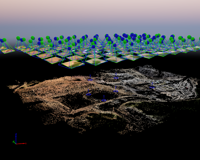
The start of this lab was similar to the previous one, the initial processing of the map was done without the use of GCPs and then these points were added into the program in order to make the necessary adjustments. In order for the program to be able to adjust the map, the user must go through the various GCPs and select their exact center. By doing this it provides Pix4D with an idea of where the center of the control point is, and the center point has known coordinates used to make the adjustments. The program takes an overall average of the points the user selects to be the center, and selecting too many center points for the same GCP can overwhelm the program and lead to an increase in the inaccuracy of the data rather than decreasing it. For this reason, when a series of photos are shown with the same GCP, once the first two or three should be used to select center points and the program can automatically detect the rest. Figure 1 below shows the product after initial processing but before adding the GCPs.
Figure 1: Initial Processing
Figure 2: Selecting GCP Center Points
After the processing, we then added the GCPs to the program. In order to do this, we had to let the Pix4D know which were X values and which were Y values and what the elevation value was. It is important to select the correct values otherwise the final product will be inaccurate. From the figures below, it is very obvious how significantly the final product was effected as the elevation changed quite a bit. In the figures below, the blue points are the original result and the green points represent the current elevation that has been corrected due to the inclusion of GCPs.
Figure 3: GCP Elevation Change
Figure 4: Elevation Change Overview
Figure 5: Close up of Elevation Change
Now that the inclusion of the ground control points is complete, the next stage of the lab is to complete the maps that demonstrate the significance of GCPs and show the results from this flight.
Part 3 (Discussion):
Figure 6: DSM
Figure 7: Map
Below is a link to the quality report that Pix4D outputs after it finishes processing. This report shows how little error there was in the data, with an RMS error of .045m. Further down one can also note the accuracy of the individual ground control points.
Part 4 (Conclusion):
Based on the evidence from the maps above and the data from the quality report, the advantages of GCPs are clear. Even though for this lab the only real change was seen in the elevation it is still a more accurate model because of the control points. The difference in the data elevation was about 26 meters which is a very large number and would greatly affect the data. This shows that it benefits the user to use GCPs in order to gather the most accurate and reliable data for every flight.


Comments
Post a Comment