Lab 11: UAS Mission Planning
Introduction
For this platform, the pre-flight checklist is critical and essential. There is a hard transition between when we are in control of the platform and when it is fully autonomous because of the way the Bramor is designed. Once it is launched from the catapult the system is in charge of itself, so before that point, we must ensure that all steps were performed properly. From folding the parachute to removing the "remove before flight covers" and ensuring the flight plan is correct, the pilot must be confident that all the steps were performed before takeoff.
The essential parts of mission planning for the system are understanding the various transitions the Bramor goes through during the flight. From takeoff to the takeoff point, then transitioning to the mission, then to the rally point and finally the parachute point. These transitions are the critical moments of the mission where things could most likely go wrong. Wind direction, altitudes, obstacles, and the general surrounding area must all be taken into consideration when creating the mission. One thing to keep in mind during the flight is the ability to manually pop the parachute and move the transitioning points. If wind direction changes or sometime during the mission the pilot decides to change the parachute and landing points, these changes can be made. Sometimes the flights are going to be lengthy and weather conditions may change during that time. Even though we do not have the ability to take manual control it is important to remember that we do have control over the UAV and if the mission hits a critical moment where the parachute needs to be manually opened that can be accomplished.
Methods
All of the following images are the missions and flight paths created per the lab requirements. The first mission was created at the Bramor test area, where images were taken to show the flight plans, mission altitudes, and speeds, and transition point altitudes. The mission was also opened in google images to show the path it would fly over satellite imagery. The second flight plan that was created was a mission that followed the road adjacent to the flight test area. This was made to show the Bramor's capabilities in mission settings. Then a mountainous area in an agriculture part of the country was chosen to demonstrate how a flight plan should be made when the terrain is a large concern. For these missions, it is important to set the flight path on the Bramor to change with the changing elevation. This is important for two reasons because not only will it allow for better data collection because all the images will have the same resolution but also because it is another safety measure to avoid terrain. As long as the platform is attempting to stay a certain altitude above the ground it will not be flying into the ground, so in case an error was made in the altitude settings for the flight this will help avoid complications. Next was planning a mission in County Amphitheatre Park here in Lafayette. Planning this mission taught us how to account for wind direction when there are limited spots for landing. Switching to satellite data showed us which areas were suitable for taking off and landing, and choosing the right rallying points so as to not fly over roads, buildings, people, or obstacles was very important. Finally, I chose to plan a flight over an area in San Diego. I chose a spot at a public park I knew had plenty of area for the Bramor to take off and land from and had enough wide open space with no obstacles or other concerns that it would be a safe and uneventful flight.
Image 1: Flight plan overview Bramor test field
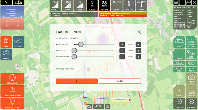
Image 2: Bramor test field takeoff altitude
Image 3: Bramor test field parachute point
Image 4: Bramor test field mission settings
Image 5: Bramor test field flight plan overhead
Image 6: Bramor test field flight plan side view
Image 7: Bramor test field road following overview
Image 8: Bramor test field road following flight path
Image 9: Ag-mountain flying flight plan
Image 10: Ag-mountain flying flight path overview
Image 11: Ag-mountain flying flight path side view
Image 12: County Amphitheatre Park flight plan
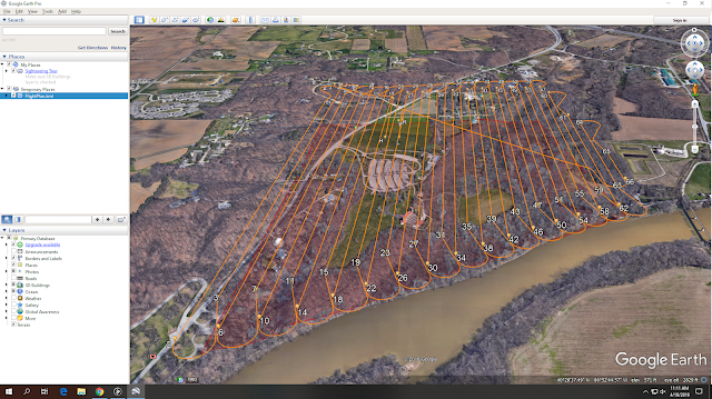
Image 13: County Amphitheatre Park flight path overview
Image 14: San Diego flight plan
Image 15: San Diego flight path overview
Image 16: San Diego flight path side view
Overview
Before the moment of takeoff, it is important to have confidence in your preflight checklist and planning. The checklist that was provided with the Bramor is crucial and following it step by step is mission critical, but it also has its limitations, such as a few minor translation issues. Every system is different and ours is no exception, it is important to understand the limitations of the checklist before a flight. When performing the preflight checks this is the time to perform the final review of your created flight plan. Looking at altitudes, wind direction, and the surroundings while getting the Bramor ready for a flight might lead to some changes in the mission. Such tasks like pointing the catapult into the direction of the wind and confirming the direction of the wind a series of times could also lead to a change in the parachute point.
Conclusion
In general, mission planning is important because it takes the load off the pilot in flight. The more planning that was done prior to the mission the less distracted and panicked the flight itself will be, and the more the pilot can be focused on flying the platform. The Bramor is slightly different because there is no manual control of the aircraft. This means that the preflight planning is critical because once it takes to the sky there is no way to manually land the platform. Therefore all aspects of the mission must be taken into consideration before launch as this is a hard transition that cannot be undone if mistakes were made in the preflight checks or mission planning.


Comments
Post a Comment